Klik -
her eller under teksterne for at komme videre!
Mexico ifølge Lonely
Planet
Mexico is a land of extreme diversity: the superficial glitz of fly-in, fly-out tourist resorts coexists with awe-inspiring ancient cities, and snow-capped volcanoes slope down to pine forests, deserts and balmy tropical beaches. The bursting industrial megalopolis of Mexico City is a one-hour flight from the resource-rich southern state of Chiapas, where Indian insurgents recurrently tangle with the ruling party's paramilitary forces. Up along the northern border, Mexico's disorienting tumult of heritages merge with the air-conditioned cultures of California, Arizona, New Mexico and Texas.
Mexico's landscape and its people reflect the country's extraordinary history - part Indian, part Spanish. One look at this country is enough to remind visitors that there is nothing new about the so-called New World. Despite the considerable colonial legacy and rampant modernization, there are still over 50 distinct indigenous peoples, each with their own language, maintaining vestiges of their traditional lifestyles.
In Mexico City, crime has reached critical levels, with marked increase in the level of violence, as well as a significant incidence of sexual assaults in crimes committed against women. The most frequently reported crimes involve taxi robberies, armed robbery, pickpocketing and purse snatching.
Travelers to Oaxaca and Chiapas should restrict their itineraries to the main tourist routes, maintain a high level of personal security awareness and contact their embassy in Mexico City before traveling to these sometimes violent states.
Area: 1,972,000 sq km (769,080 sq mi)
Population: 100,294,036 (growth rate 1.73%)
Capital city: Mexico City (22 million people)
People: Approximately 80% mestizo (mixed European and Indian descent) and 10% indígena (Native Americans or Indians - including Nahua, Maya, Zapotecs, Mixtecs, Totonacs, and Tarascos or Purépecha)
Language: Spanish and over 50 indigenous languages
Religion: 90% Roman Catholic, 6% Protestant
Government: Democracy
President: Vincente Fox Quesada
GDP: US$815.3 billion
GDP per head: US$8300
Annual growth: 4.8%
Inflation: 18.6%
Major industries: Food and beverages, tobacco, chemicals, iron and steel, petroleum, mining, textiles, clothing, motor vehicles, consumer durables, tourism
Major trading partners: USA, Canada, Japan
Visas: Citizens of many countries - including the USA, Canada, Australia, New Zealand, Japan, Argentina, Chile and virtually all Western European countries - do not require visas to enter Mexico as tourists. However, they must obtain a Mexican government tourist card (tarjeta de turista), available from embassies or at border crossings. Travelers entering Mexico from Guatemala or Belize are often given only 15 days on their tourist cards.
Health risks: Cholera, dengue fever, hepatitis, malaria, polio, rabies, tetanus, typhoid. Air pollution in Mexico City is extremely high between December and May.
Time: Most of Mexico is on Central Standard Time (6 hours behind UTC). Baja California Sur and several other states in the northwest are on Mountain Standard Time (7 hours ahead of UTC) and Baja California Norte is on Pacific Standard Time (8 hours ahead of UTC).
Electricity: 110V, 60Hz
Weights & measures: Metric
Tourism: Estimated 16.5 million visitors per year
AEROP. INTERNACIONALMEXIC, MEXICO
Located at about 19.43°N 99.00°W. Height about 2234m / 7329
feet above sea level.
Average Rainfall i mm
|
Jan |
Feb |
Mar |
Apr |
May |
Jun |
Jul |
Aug |
Sep |
Oct |
Nov |
Dec |
|
8.1 |
5.2 |
11.4 |
19.4 |
48.7 |
105.8 |
128.5 |
121.0 |
109.6 |
44.3 |
15.3 |
6.5 |
|
Jan |
Feb |
Mar |
Apr |
May |
Jun |
Jul |
Aug |
Sep |
Oct |
Nov |
Dec |
|
12.9 |
14.5 |
16.4 |
18.1 |
18.7 |
17.9 |
17.2 |
17.1 |
16.7 |
15.6 |
14.2 |
13.0 |
Mexico's climate varies according to the country's topography. It's hot and humid along the coastal plains on both sides of the country, but inland, at higher elevations (such as in Guadalajara or Mexico City), the climate is much drier and more temperate.
The hot, wet season is May to October. The southern coastal regions can be uncomfortably hot and extremely humid between July and September. Unless you want to do nothing but lie on the beach and avoid occasional downpours, it's best to avoid the southern coast of Mexico during these months - especially since July and August are also the peak holiday months for foreign visitors and the coastal resorts attract large numbers of tourists.
October to May is the most pleasant time to visit since it is fairly dry and still comfortably warm. December to February are generally the coolest months, but north winds can make inland northern Mexico decidedly chilly, with temperatures sometimes approaching freezing. The peak domestic travel periods are Semana Santa (the week before Easter) and Christmas/New Year, when facilities are often heavily booked.
Mexico's frequent fiestas are full-blooded, highly colorful affairs that often go on for several days and add a great deal of spice to life. There's a major national holiday or celebration almost every month, to which each town adds almost as many local saints' days and fairs. Carnaval (Carnival), held late February or early March, the week or so before Ash Wednesday, is the big bash before the 40-day penance of Lent. Día de los Muertos is held on 2 November (when the souls of the dead are believed to return to earth), and is perhaps Mexico's most characteristic fiesta. Families build altars in their homes and visit graveyards with garlands and gifts to commune with their dead ancestors. Sweets resembling human skeletons are sold in almost every market.
Currency: Peso
Meals
Budget: US$3-5
Mid-range: US$5-15
Top-end: $15 and upwards
Lodging
Budget: US$8-15
Mid-range: US$15-30
Top-end: US$30 and upwards
Your costs will also depend on where you spend your time: Mexico's big cities and coastal resorts are much more expensive than rural areas. If you take in a mix of these places, budget travelers should be able to squeeze by on around US$20-30 a day. Traveling in reasonable comfort, staying at the better mid-range places and eating at the more expensive restaurants should cost around US$60 per day. You'll spend a lot more than this if you stay at luxurious hotels and hire a car occasionally.
It's best to bring US-dollar denomination traveler's checks and some US dollars in cash. You can exchange money in banks or in casas de cambio. Note that bank exchange facilities are often only open between 9 or 10 am and noon or 1 pm. Exchange rates vary a little from bank to bank. Major credit cards are accepted by airlines, car rental places and more expensive hotels and restaurants. In heavily touristed areas such as Acapulco, Cancún and Cozumel, you can often spend US dollars as easily as pesos at hotels and restaurants (although the exchange rate will probably be awful). Note that the dollar sign is used to refer to pesos in Mexico so don't mix it up with US dollars which are usually marked US$ or USD.
Mexico has a 15% value-added tax (IVA) but by law this tax must be included in quoted prices. Sometimes - usually in top-end hotels - a price is quoted without this tax. Tipping in restaurants in resort areas is equivalent to US levels - somewhere between 15% and 20%. Outside these areas, a tip of 10% is sufficient at mid-range or quality restaurants; in general, staff at smaller, cheaper places do not expect a tip. Expect to bargain at markets and with drivers of unmetered taxis. Treat haggling as a form of social discourse rather than a matter of life and death.
Mexico City is a place to love and loathe. It has everything you might expect from the world's largest metropolitan area and second-largest city. Like mysterious ingredients added to a bubbling cauldron, the best and the worst of the country have been combined in the high valley where Mexico City sprawls. The result is a polluted and bustling cosmopolitan megalopolis of music and noise, brown air and green parks, colonial palaces, world-renowned museums and spreading slums.
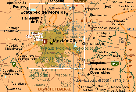
The historic center of Mexico City is the Plaza de la Constitución, more commonly known as the Zócalo. The plaza was first paved in the 1520s by Cortés with stones from the ruins of the temples and palaces of the Aztec city of Tenochtitlán, the site on which Mexico City was built. Tenochtitlán was built in the middle of a lake, so many of Mexico City's older buildings and churches are sinking into the boggy ground on which they were constructed. Filling the entire eastern side of the Zócalo is the Palacio Nacional (National Palace), built on the site of an Aztec palace and formerly used to house the viceroys of New Spain. It is now home to the offices of the president, a museum and the dramatic revolutionary murals of Diego Rivera, which chronicle Mexico's history.
The Catedral Metropolitana, on the northern side of the Zócalo, was built by the Spaniards in the 1520s on the site of the Aztecs' Tzompantli, or Wall of Skulls (a sort of altar on which the skulls of the sacrificed were placed). Just east of the cathedral are the remnants of the Templo Mayor, the Aztecs' principal temple, and the stunning museum that houses the artifacts discovered at the site.
The Alameda, which was once an Aztec marketplace, is now a pleasant and verdant park. The streets around the Alameda are lined with colonial mansions, skyscrapers, lively cafés, restaurants, shops and markets. Other must-sees include the Bosque de Chapultepec, Mexico City's largest park, which is home to a handful of museums, amusement parks and the official residence of the president; the Basilica de Guadalupe, the church built on the spot where Mexico's patron saint was seen in a vision; the colonial houses of San Ángel; the Cuicuilco pyramid; and the canals of Xochimilco.
Plaza Garibaldi is where the city's out-of-work mariachi bands gather in the evenings, and the Zona Rosa is the highlife and nightlife district. The best moderately priced hotels are found in the areas west of the Zócalo and south of the Alameda. Excellent cheap food can be found in most areas of the city.
Only 50km (31mi) northeast of the city center lie the ruins of Mexico's biggest ancient city, Teotihuacán, which probably boasted 200,000 inhabitants at its peak in the 6th century. Teotihuacán was the capital of Mexico's first great civilization, and the remains testify to its pre-eminence. Travelers who can avoid the touts will be in awe of the Avenue of the Dead, the 70m (230ft) high Pyramid of the Sun, the Pyramid of the Moon and the Palace of the Quetzal Butterfly.
Tula, the probable capital of the Toltec civilization, is 65km (40mi) north of Mexico City. The site is best known for its fearsome 4m (13ft) high stone warriors.
Some 85km (53mi) south of the capital is Cuernavaca, a city whose mild climate has attracted the wealthy and fashionable seeking relief from Mexico City since colonial times. Much of the city's elegance is hidden behind high walls and courtyards, but a number of residences have been turned into galleries, hotels and restaurants. The city is not for those on a tight budget but its luxuries make it a favorite place for visitors keen to enroll in Spanish-language courses.
The old silver-mining town of Taxco, 180km (112mi) southwest of Mexico City, is a gorgeous colonial antique, and one of the most picturesque and pleasant places in Mexico. It clings to a steep hillside, has labyrinthine narrow cobbled streets, engagingly well-worn buildings and delightful plazas. The entire town has been declared a national historic monument.
Despite its beautiful coastline of fine white beaches, peaceful bays and imposing cliffs, the interior of Baja is harsh and undeveloped and has always been a good place to hide. The peninsula has been a hideout for Magonista revolutionaries, mercenaries and drinkers looking for lairs during Prohibition in the USA. These days it is tourists who escape to Baja. Highlights include San Borja, a remote mission village founded by Jesuit missionaries; the Sierra de San Francisco near San Ignacio, a volcanic plateau containing extraordinary rock-art sites and recently declared a UNESCO World Heritage area; and the Sierra de la Laguna, a botanical wonderland at the southern tip of the peninsula where aspens, cacti, oaks and palms grow side by side and where mountain streams rush through granite canyons - a paradise for hikers.
The journey between Los Mochis and Chihuahua is one of the most scenic in Mexico. The railway goes through 88 tunnels and over 38 bridges as it cuts through small canyons in the Sierra Tarahumara and hugs the sides of towering cliffs. The railway is a considerable feat of engineering and, not surprisingly, took 90 years to build. The trip is a whirlwind of dramatic geological images, the best of which is Copper Canyon, deeper and grander than Arizona's Grand Canyon. Intrepid hikers can arrange to descend the 2300m (7544ft) deep canyon with guides from Creel or nearby Divisadero.
Nestled beside the Río Caule between palm-covered mountains and the azure Bahía de las Banderas (Bay of Flags) is the picturesque, cobble-stoned, whitewashed city of Puerto Vallarta, a favorite of both the ultra-rich and the shoestring traveler.The city boasts white-sand, palm-fringed beaches, lively bars and restaurants and heaps of galleries and handicrafts.
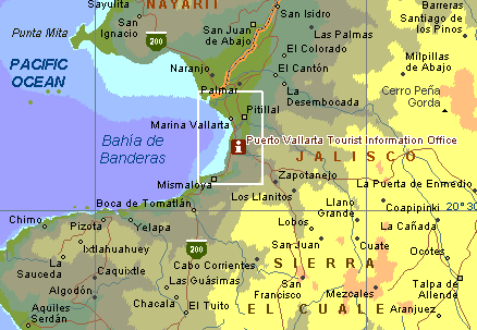
The city has mutated from a sleepy seaside village to an international resort so quickly that it is fashionable to deride its spoilt charms, but it's almost impossible to dislike its quaintness, southern beaches, immense bay and marine life. There are dolphins in the bay year-round, and pilot and grey whales between February and April. Locals insist that if you stand on the seafront in April, you can see giant manta rays leaping into the air during their mating rituals.
Many of the features and traditions considered characteristically Mexican were created in Guadalajara, the second-largest city in Mexico. They include mariachi music, tequila, the Mexican Hat Dance, broad-brimmed sombrero hats and the Mexican rodeo. Part of Guadalajara's appeal is that it has many of the attractions of Mexico City - a vibrant culture, fine museums and galleries, exciting nightlife and good places to stay and eat - but few of the capital's problems.
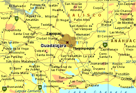
Guadalajara is bright, modern, well-organized and unpolluted and has so many attractions and things to do that visitors never get bored. Highlights include the giant, twin-towered cathedral and the lovely surrounding plazas, the Instituto Cultural de Cabañas, the Plazuela de los Mariachis - where bands play all hours of the day and night - and the free samples handed out during tours of the Tequila Sauza Bottling Plant.
The first and most famous of the resort cities on Mexico's Pacific coast was once the New World's gateway to the Orient, but today it's a fast-growing city of well over a million inhabitants with a schizophrenic mixture of high-rise hotels, designer shopping plazas and tri-lingual restaurants shielding a hidden city of auto-parts stores, polluted rivers and crowded apartments. The city is definitely not everyone's idea of fun, but most visitors to Acapulco are happy to laze on the city's numerous beaches, which offer equipment for just about every sport that can be done on or under the water.
The famous cliff divers of La Quebrada have been amazing visitors since the 1930s with their graceful finesse as they dive from the seemingly suicidal height of 45m (148ft) into a narrow crevasse, which appears to contain only enough water to wash their feet. Not surprisingly, the divers pray at a small shrine before flinging themselves into the void. You can get a great view of the divers from the bar of the El Mirador Hotel. For less crowded beaches, try the Pie de la Cuesta, 8km (5mi) northwest of the city center, which is a good alternative to the glitz of the city. There are great views of Acapulco's bay on the road to Puerto Marqués, 18km (11mi) southeast of the city. Just south of the Peninsula de las Playas is the so-called underwater shrine, a submerged bronze statue of the Virgin of Guadalupe.
This Spanish-built city of narrow streets has a special atmosphere - at once relaxed and energetic, remote and cosmopolitan. Situated in the rugged southern state of the same name, the city has a large indigenous population, and Indian markets meld with the city's superb colonial architecture.
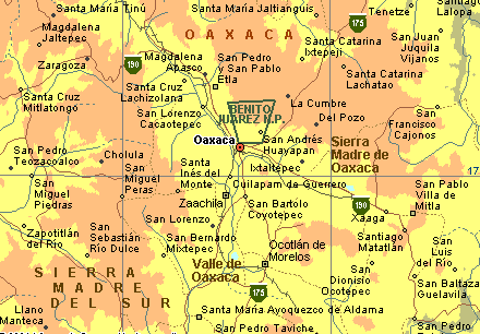
Not least of the city's attractions are the abundant local handicrafts and the conviviality of the local cafés. There are many fascinating places within day-trip distance of the city, notably the ruins at Monte Albán, Mitla, Yagul and Cuilapan, and the village markets and craft centers.
When you cross the Río Usumacinta into Yucatán, you are crossing into the realm of the Maya. Heirs to a glorious and often violent history, the Maya live today where their ancestors lived a millennium ago. Yucatán has surprising diversity: archaeological sites galore, colonial cities, seaside resorts and quiet coastlines populated mostly by tropical birds.
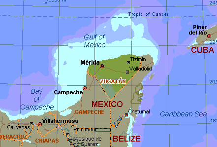
There are impressive Mayan sites near Mérida at Uxmal and Chichén Itzá. The coastal state of Quintana Roo, with its islands and white-sand beaches, attracts sun-loving tourists.
Most visitors to Mexico arrive by air and there are relatively cheap connections to Canada, the Caribbean, the rest of Latin America and the USA. Aeroméxico and Mexicana are the largest Mexican airlines. There's a departure tax of approximately US$12.50 if you purchase your air ticket in Mexico.
Travelers can cross into Mexico by road from the USA at one of the 20 official crossing points. US buses connect with Mexican buses at the border. There are three border crossings between Mexico and Guatemala (road and rail). There are also a couple of little-known and relatively hair-raising jungle routes via back-country bus and riverboat. One leaves from Guatemala's Tikal area and enters Mexico at Corazal, the other comes from Fores in Guatemala's El Petén to Tenosique in Tabasco. Both terminate at Palenque in Chiapas. Travelers should check the security situation in Chiapas with their embassy before attempting this crossing. There is one road border crossing point between Mexico and Belize near Chetumal and Corozal.
Flights in Mexico are no longer particularly cheap, although flying still represents good value for the money, especially considering the long, hot bus trip that may be the alternative. In recent years, the large airlines have left many of the domestic routes to smaller carriers. However, these start-up airlines and their timetables are particularly volatile; new ones are founded and older ones flounder at an alarming rate.
Buses are the most common mode of transport and bus routes are extensive. Long-distance buses are fairly comfortable, air-conditioned and acceptably fast. Local rural buses tend to be ancient, decaying, suspensionless models grinding out their dying years on dirt tracks. Combis, collectivos and peseros are minibuses used for local transport.
US driving licenses are valid in Mexico, and driving a car can be a good way to get to some of the most beautiful and isolated towns and villages, although you need to be forgiving of road conditions. In Mexico City, car use is restricted to lessen air pollution: the timetable for car use is based on the last digit of the license plate (eg, if your license plate ends with the number 5 or 6, you cannot drive on a Monday; if it ends with 7 or 8 you cannot drive on Tuesday, etc).
Car and passenger ferries connect Baja California with the Mexican mainland; ferries also run between the mainland and the Caribbean islands of Isla Mujeres and Cozumel. The government is privatizing Mexico's railways, and passenger services on many lines have ceased. Where they still exist, trains are usually cheaper (and much slower) than the bus, but vary between relatively comfortable and downright unsafe. The good news is that the spectacular Copper Canyon Railway (Ferrocarril Chihuahua al Pacífico), between Chihuahua and Los Mochis has been privatized but is still operating.
![]()
![]()